- Find a Grave website
- Ekfrid Cemeteries
- Mosa Cemeteries
- Metcalfe Cemeteries
- Caradoc Cemeteries
- List of cemeteries in the district
The Historical Society maintains a wealth of information pertaining to local cemeteries and family plots. We maintain records for each cemetery, including plot layouts, funeral records, municipal records, and information provided by families. The information provided on this website is for general assistance: for more thorough, accurate and complete information please visit our facilities in Glencoe Ontario.
Ekfrid Township Cemeteries
E1 – LOTAN
(LOWT-en)
- Location: 5472 Century Drive (Concession 4 Lot 10)
- Status: Abandoned
- Approx 33 burials (dates: 1850 – 1970)
- Travelling north on Thames Rd, turn right on Century Drive. Cemetery is located on LH side beside the road. Metal farm gate marked LOTAN. Three rows of stones mounted on cement pad.


E2 – APPIN (AH-pĭn)
- Location: Thames Road (Concession 2, Lot 12)
- Status: Active
- Approx 1000+ burials (dates: 1914 – present)
-
The cemetery land was procured in 1914 and a company was formed, Appin Cemetery Co. Ltd., by a group of community members. Eleven men agreed to pay $15 per share to form the company to purchase the land. The property, 4 acres plus roadway, was purchased for $400.00.
The price of a plot, which included 8 burial sites, was $15.00. Several families representing early shareholders, (Johnson, McFee, May), purchased large family plots with 32 graves each. This provided early operating funds for the new company. More here.
Directions: From Glendon Drive turn north on Thames road as you leave Appin. Well marked entrance on your RH side between Glendon and Falconbridge. Cemetery is located up a long straight laneway.


E3 – EDDIE (EE-dee)
- Location: Glendon Drive (Concession 2 Lot 18)
- Status: Active
- Approx 300+ burials (dates: 1845 – present)
- Travelling southwest on Glendon, right-hand side on a hill between McArthur and Tait’s Road.


E4 – MAYFAIR COVENANTED BAPTIST
- Location: Longwoods Road (Range 1 South, Lot 8)
- Status: Active
- 220+ burials (dates: 1828 – present)
- Travelling southwest on Longwoods, right on the corner of Longwoods and Mayfair, beside the church.


E5 – McKELLAR
- Location: 5465 Riverside Drive (Range 5 South, Lot 10)
- Status: Abandoned
- Approx 3 burials (dates: 1856 – 1925)
- Travelling southeast on Mayfair Road, turn right on Riverside Drive. Follow the road until it ends (short distance), it turns into a private drive leading to barns. The plot is on the RH side beyond the barns and across the field at the tree line, barely visible from the barns. The plot is surrounded by a low cement wall. (Private Property).


E6 – MURRAY
- Location: 5693 Mayfair Rd (Range 5 South, Lot 8)
- Status: Active
- 200+ burials (dates: 1828 – present)
- Travelling southeast on Mayfair Rd, turn left on Riverside Drive. On the RH side is a farm. Follow the lane behind the barn, over the culvert, and round the bend. The cemetery is located in a grove of trees.


E7 – McRAE
- Location: 3874 Hyndman Drive (Range 2 South, Lot 23)
- Status: Abandoned
- Approx 4 burials (dates: 1862 – 1914)
- Travelling south on Taits Road, turn right on Hyndman Drive. Prior to reaching Dundonald Road, the cemetery is on the RH side far out in the center of the field. Two tall stones might be visible from the road. (Private Property)
Note: These stones were relocated to Willey Cemetery in 1980, but were then returned to the McRae cemetery.


E8 – McLACHLIN
- Location: Range 4 South, Lot 10
- Status: Abandoned
- Some records indicate location Range 5 South, but actual location is Range 4 South between Gentleman and Riverside Roads.
- Travelling south on Thames Road, turn left on Gentleman Drive. You will pass the Willey cemetery on your right. Prior to reaching Mayfair Road (and a large gulley) there is a farming access road on the RH side. This access road divides lot 10, with a field on either side of the dirt road. The access road goes back to a cluster of trees. The family plot was located on the left of the road near the trees. (Private Property)
- No stones or indications of cemetery remaining.


E9 – BETSY SHAW McCALLUM
- Location: Range 1 South, Lot 20
- Status: Abandoned
- single burial
- *** see E-11 Betsy Shaw McCallum ***
E10 – WILLEY (WILL-ee)
- Location: 5267 Gentleman drive (Range 4 South, Lot11)
- Status: Abandoned
- Approx 100 burials (dates: 1856 – 1915)
- Travelling south on Thames Rd, turn left on Gentleman Drive. Cemetery is located on RH side. Stones are mounted on a large cement pad. A historical plaque has also been erected.
Note: In addition to the original Willey cemetery, several other small cemeteries were relocated to this location. This includes:
- McCallum (Range 1 South, Lot 16)
- Tammico-McCallum (Range 4 South, Lot 12)
- Phillips (Range 4, Lot 18)


E11 – McCALLUM relocated to WILLEY
- Location: Range 1 South, Lot 16
- Status: Abandoned, Relocated
- Some records indicate location Lot 20 beside Taits Rd, but actual location is Lot 16 beside McArthur Rd.
- Approx 3 burials (dates: 1849 – 1863)
- Travelling Southwest on Longwoods Rd, turn left on McArthur Road. The plot was located in the field on the LH side (east). There is a large tree on the side of the road, the plot was located about 200ft in the field. There is a slight rise in the field, and the ground is a bit sandy at this location. There are no stones or indications of cemetery remaining.
- Graves relocated to Willey Cemetery.
- Inground marker near base of stone in Oakland Cemetery.


E12 – TAMMICO – McCALLUM relocated to WILLEY (TOM-ick-oh, TAHM-ick-oh)
- Location: Range 4 South, Lot 12
- Status: Abandoned, Relocated
- Approx 10+ burials (dates: 1850 – 1904)
- Travelling South on Thames Road pass Gentleman Drive. There is a large bend in the road prior to the bridge that crosses the Thames river. Thames Road used to go straight and then turned at a corner closer to the river. Where the current road begins its long curving bend you can still see the remains of the old road bed going off into some bush. Following the road bed into the bush about 500ft (southeast) is a meadow on the left. Across the meadow (southeast) is a line of trees and a steep drop to a cultivated field below. The cemetery was located at the top of this steep drop among the large walnut trees.
- There are no stones or indications of cemetery remaining. (Private property)


E13 – PHILLIPS relocated to WILLEY
- Location: Range 4 South, Lot 18
- Status: Abandoned, Relocated
- Approx 2 burials (dates: 1844 – 1849)
- Travelling south on Taits Road, turn left on Dobie Drive. This road used to continue across the fields and connected to Gentleman Drive but it was closed long ago and ends quite abruptly. Following the path that the road used to take, the cemetery was located to the left (northeast). (Private property)


Additional Small Private Plots – Very Limited Information
- McLellan
– Location: South Gore Rd (Trillium), Lot 24 - Simpson – Goff
– Location: N/S Gore (Trillium), Lot 23
Mosa Township Cemeteries
M1 – OAKLAND
- Location: Longwoods Road (Range 1 North, Lot3)
- Status: Active
- Approx 1500+ burials (dates: 1894 – present)
- Travelling southwest on Longwoods Rd, between Dundonald Rd and Old Airport Rd on the RH side beside the road.


M2 – ST. ANDREWS (GRAHAM)
- Location: 112 Main Street Glencoe (Concession 1, Lot 1)
- Status: Abandoned
- Approx 500 burials (dates: 1841 – 1931)
- Entering Glencoe on Dundonald from Longwoods Road, pass Parkhouse drive (on your right) and pass 4 houses on your left. The cemetery is located behind a small white house on your left.


M3 – WALKER
- Location: Concession Street, Glencoe (Concession 2 Lot 1)
- Status: Abandoned
- 1 burial (date: 1839)
- Travelling southwest on Concession Road from Glencoe, located across the road from Glencoe High School. Narrow piece of land beside the road surrounded by chain-link fence. There is one tombstone and a memorial stone.


M4 – SIMPSON
- Location: Pratt Siding Road (Range 2 South, Lot 9)
- Status: Active
- Approx 400+ burials (dates: 1860 – present)
- From Longwoods Rd, turn southeast on Pratt Siding Road. Pass Riverside Drive, go down a steep hill, the cemetery is on the RH side beside the road.


M5 – BIG BEND-DEPEW
(MOSA TOWNSHIP MEMORIAL)
- Location: 2269 Longwoods Road (Range 1 South, Lot 12)
- Status: Abandoned
- Approx 400 burials (dates: 1836 – 1906)
- East corner of Longwoods Rd and Big Bend Rd. Travelling southwest on Longwoods Rd it is on the LH side beside the road. Small cemetery, stones arranged in a square wall.


M6 – CHURCH OF THE NORTH AMERICAN MARTYRS
(WARDSVILLE ROMAN CATHOLIC, ST THOMAS OF CANTERBURY)
- Location: Range 1 North, Lot 16
- Status: Active
- Approx 400+ burials (dates: 1840 – present)
- Travelling southwest on longwoods road, turn right on Ontario just as you enter Wardsville. Ontario goes up a large hill, cemetery located on top.


M7 – WARDSVILLE MUNICIPAL CEMETERY
- Location: Kennedy Street, Wardsville (Range 1 South, Lot 16)
- Status: Abandoned
- Approx 1000 burials (dates: 1829 – 1986)
- Travelling west on Longwoods Rd (Hwy2), enter Wardsville and turn left on Kennedy St.


M8 – ST. JAMES ANGLICAN
- Location: Corner of Hagerty and Church Street, Wardsville (Range 1 North, Lot 16)
- Status:Abandoned
- Approx 200 burials (1873 – 1909)
- This cemetery is located at Little Kin Park. A large memorial stone commemorates the Anglican church and lists those buried in the cemetery.


M9 – ARCHER-O’MALLEY
- Location: Hagerty Road (Range 1 North, Lot 17)
- Status: Abandoned
- Approx 25 burials (dates: 1862 – 1961)
- Travelling north on Hagerty Road out of Wardsville, the cemeteries are on the LH side in the center of Lot 17. It is two family cemeteries, one surrounded by an ornate iron fence. (Private Property)


M10 – CASHMERE
- Location: 695 Longwoods Rd (Range 1 South, Lot 26)
- Status: Abandoned
- Approx 250 burials (1832 – 1915)
- Travelling southwest on Longwoods Rd, pass Sassafras Rd. On your LH side, almost underneath Ontario Hydro wires. Gray granite memorial stone set near the back of a lawn, trees on either side.


M11 – GARDINER (GIBB, TAYLOR)
- Location: 450 Longwoods Road (Range 1 North, Lot 28)
- Status: Active
- Approx 150+ burials (dates: 1860 – present)
- Travelling southwest on Longwoods, go through Wardsville, pass Cashmere Rd, continue for 0.7km. Small cemetery on the RH side beside the road.


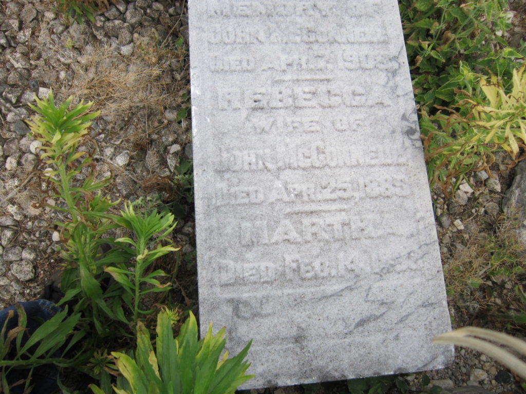
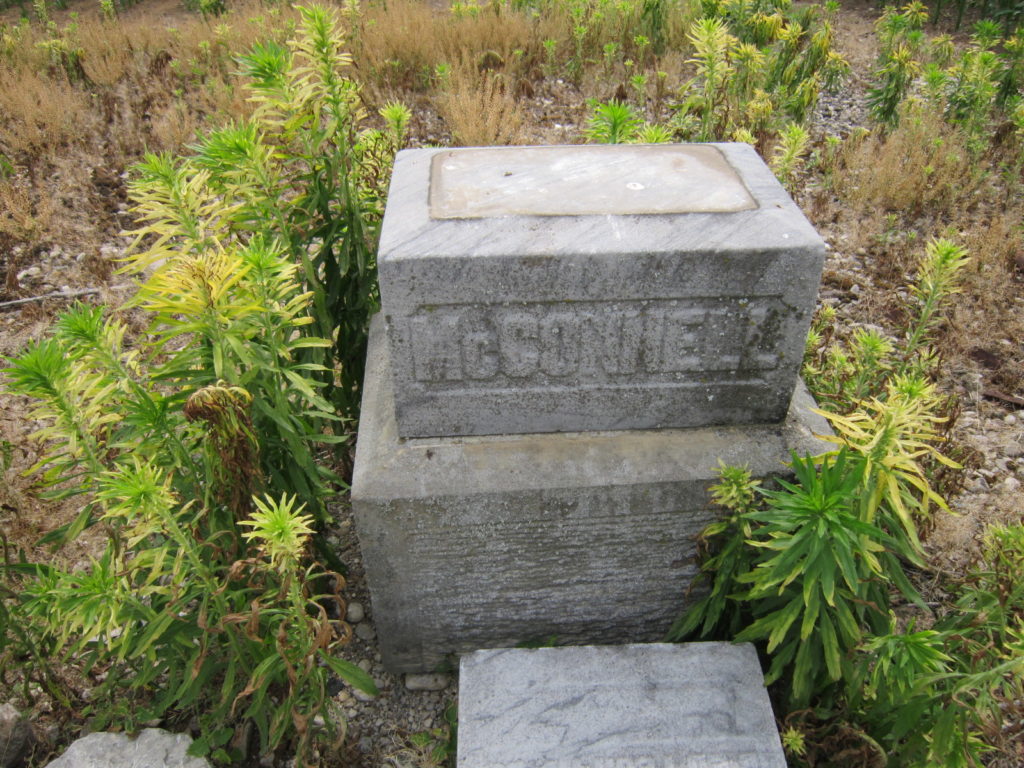
M12 – McCONNELL – THOMPSON
- Location: CPR Drive (Concession 4 Lot 12)
- Status: Abandoned
- Approx 5 burials (dates: 1884 – 1908)
- Travel North out of Glencoe on Dundonald, turn left on CPR Road. Pass Old Airport Road and Pratt Siding Road. Just prior to Big Bend Road is a field on the RH side. The plot is out in the middle of the field. If you turn right onto Big Bend Road and travel 2/3 of the way to the rail tracks you will be much closer to the plot. (private property). There is no path or laneway. In the summer when the field is planted, impossible to find


M13 – CARSWELL
- Location: Buttonwood Road (Concession 10, Lot 6)
- Status: Abandoned
- Approx 100 burials (dates: 1846-1893)
- Travel North on Dundonald (Hwy 80) out of Glencoe, turn left on Buttonwood Drive. Cross Old Airport Road. Buttonwood becomes a very small dirt road. The cemetary entrance is on the RH side. A long laneway (about 200m) leads to the the cemetery and may be inaccesible in winter, or very soft in spring so you may need to walk. The stones are mounted on a cement pad.


Additional Small Private Plots – Very Limited Information
- McCOLLOM Family
– Range 1 South, Lot 21 - (Private)
– Concession 6, Lot 7 - McAlpine (Private)
– Concession 7, Lot 7
– 2 burials - Arnold – Edward (Private)
– Concession 5, N1/2 Lot 12 - Collier, James (Private)
– Concession 5, S1/2 Lot 15 - McGregor’s (Private)
– Concession 4, S1/2 Lot 12 - Sinclair
– Concession 11, S1/2 Lot 1 - McCallum (Private)
-Concession 6, Lot 3
– 3 burials - Glencoe-Millstone (1857)
– unknown burials
Me1 – KILMARTIN
- Location: 24452 Dundonald Road (Lot 24, Concession 13)
- Status: Active
- Approx 2000+ burials (dates: 1860 – present)
- East side of Dundonald Rd (Hwy 80) between Shields Siding and Walker Drive. Across the road from Burns Presbyterian Church.


Me2 – LEITCH (pronounced “Leech”)
- Location: Walkers Drive (Lot 14 Consession 13, N1/2)
- Status: Abandoned
- South side of Walkers Drive between Thames and Road and McArthur. 0.6km from Thames Rd. traveling southwest on Walkers Drive. A small hill with grove of pine trees on the LH side just prior
to a cement bridge. It is a small open cemetery with no stones. There is a metal plaque mounted in the rear.


Me3 – GOUGH (pronounced “Goff”)
- Location: 5018 Scotchmere Drive (Lot 14, Concession 13, South 1/2)
- Status: Active
- North side of Scotchmere Drive between Thames Rd and McArthur. Travelling North on Thames Rd, turn left on Scotchmere Drive. Small cemetery plot on the RH side of the road.


Me4 – MITCHELL
- Location: Calvert Drive (Lot 17, Concession 12, North 1/2)
- Status: Abandoned
- South side of Calvert Drive between Napier Rd and McArthur Rd. Travelling North-East on Calvert drive, the cairn is located on the right side. When you drive down a small gully it is located on a hill close to the road on the RH side. In late summer early fall can be hard to see from the road because of tall grasses.


Me5 – BROWN
- Location: Calvert Drive (Lot 7 Consession 12, North 1/2)
- Status: Abandoned
- South side of Calvert Drive between Mayfair Rd and Springfield Rd. There is a metal plaque mounted on the side of the road. A very rough access road takes you to the cemetery about 0.4km in from the road. Access during winter or spring may be quite limited.


Me6 – LAUGHTON (LAW-ton)
- Location: 6222 Inadale Drive (Lot 3, Concession 14)
- Status: Abandoned
- North side of Inadale Road between Melbourne Road and Springfield Road. 1.8km from Melbourne Rd
traveling southwest on Inadale Drive. A small rise on the RH side surrounded by fields. A rough lane leads to the cemetery about 500ft from the road. Access during winter or spring may be limited. Recommend walking the short distance up the lane.


Me7 – ST. MARY’S, NAPIER
- Location: 1418 Melwood Drive (Lot 4, Concession 5)
- Status: Abandoned
- North side of Melwood Drive between Napier Rd and Kerwood Rd. From Calvert Drive (County Rd 2) travel North on Napier Road. Travel through Napier, turn right on Melwood Drive. St. Mary’s Anglican Church and cemetery is located on the left side of Melwood Drive.


Me8 – Cairngorm
- Location: 24536 Melbourne Rd (Hwy9)
- Status: Abandoned
- West side of Melbourne Road between Calvert Drive and Walker Drive. Across the road from the yellow brick church, slightly south under a large Oak tree abount 15ft from the road. A single memorial stone commemorating 13 buried persons.


C1 – Longwood
- Location: 22338 Melbourne Road (Lot 1, Concession 1)
- Status: Active
- Approx 2000+ burials
- East side of Melbourne Rd (Hwy 9) between Irish and Parkhouse Drive.


C2 – Cook’s United Church Cemetery
- Location: 7892 Century Drive (Lot 11, Concession 2)
- Status: Active
- North side of Parkhouse Drive between Sutherland and Christina Rd. Across the road from Cook’s United Church.


C3 – Mount Carmel United Church Cemetery
- Location: 23718 Christina Road (Lot 13, Concession 6)
- Status: Active
- Within the intersection of Christina Rd and Adelaide, just north of Olde Dr. Across the road from the yellow brick church.


C4 – Campbell
- Location: 7972 Century Drive (Lot 12, Concession 5)
- Status: Abandoned
- North side of Century Drive between Christina and Sutherland Rd. A rough lane leads to the cemetery about 400ft from the road. The lane has a creek with trees on the left and a farmed field on the right. Access during winter or spring may be limited. Recommend walking the short distance up the lane.


C5 – Hess
- Location: 24089 Sutherland Road (Lot 8, Concession 2)
- Status: Abandoned
- West side of Sutherland Rd slightly south of Scotchmere Drive. Easy visibility and access from the road.